Town Historian
Town Historian
Quick On-Page Navigation:
Welcome
Whether you’re a town resident, local historian, or family genealogist, this page offers a list of resources and links to help you explore the history of our town and its people. In addition to the resources below, the Town of Van Buren is the exclusive repository of official records related to Warners Cemetery and the former rural school districts within the town. Please feel free to contact the town historian with any local history questions or comments. Thank you.
Town Historian Information
- Steve McMahon | Van Buren Town Historian
- (315) 635-3010
- Historian@VanBurenNy.gov
Town History
Early in 1781, the New York State legislature agreed to set aside some two million acres of land for the state’s soldiers, so that it could raise its quota of regiments for the American Revolution, which ended later that same year with the surrender of the British. In 1789, the state contracted with Simeon Dewitt to survey the tract, so that veterans could collect their bounties of land as rewards for their service during the war. Camillus was one of the twenty-five original towns carved out of the tract in 1790, all of which were named for the political, military and literary figures of ancient Troy, Greece, Rome and Carthage. At the time, the area now known as Onondaga County was one vast wilderness, inhabited only by the indigenous people of the Haudenosaunee Confederacy. So, few of the bounty-holders ever settled on their lands, instead selling them to speculators.
John and Lydia McHarrie were the first permanent settlers of what would become the town of Van Buren, building a log cabin in 1789 on the south side of the Seneca River about where the dam is located today in the village of Baldwinsville, known first as McHarrie’s Rifts and then as Columbia. McHarrie is the namesake of McHarrie’s Legacy, which owns and operates the Shacksboro Schoolhouse Museum. The town’s first permanent settlement was made in 1808 at Ionia (Iona Corners), where Phineas Barnes erected the first frame house. Here the first post office in town was established in 1816, near where the Memphis post office stands today. But, it wasn’t until 1829 that the town was formed from the northern half of the town of Camillus and named for the then president of the United States, Martin Van Buren, a native of New York State.
Beyond Ionia (Iona Corners), early hamlets in the west of the town included Bangall or Sand Springs (Whiskey Hollow) and Jack’s Reef. In the south, they included Canton (Memphis) and Van Buren Center (Warners). These two hamlets owe their early growth to the completion of the Erie Canal in 1825, which ran through Memphis and near Warners (at Newport) on the southern boundary that separates Van Buren from Camillus. The canal’s successor, the New York State Barge Canal, together with the Seneca River forms the northern boundary of the town today. Lock #24 of the barge canal, located in Baldwinsville, opened in 1910. Beyond these artificial waterways, the town boasts several natural water features. Two tributaries that flow into the Seneca River from the south are Crooked Brook, which drains the hills around Van Buren Town Park, and Dead Creek, fed by White Bottom Creek and first known to the Haudenosaunee as Camp Brook. There are several springs surrounding Dead Creek, the most prominent of which can be found at Whiskey Hollow.
Early farmers of the town supplemented their field crops and dairy herds with tobacco, grown as a cash crop and shipped downstate for cigar-making. Beyond agriculture and the businesses associated with both canals, early industries in the town included several sawmills, a pottery works and a brickyard. Today, the town includes several housing developments, like the Ford tract on the southwest side of the village of Baldwinsville, Harbour Heights, Seneca Knolls, Village Green, Sun Meadows and the McHarrie Towne retirement community. Its schools include Van Buren Elementary on Ford Street, McNamara Elementary on O’Brien Road, Reynolds Elementary in Village Green, and Ray Middle School on Van Buren Road. Popular parks include Van Buren Town Park on Canton Street Road and Lions Park on Maple Road, maintained by the village of Baldwinsville. The town of Van Buren has a rich history, which you can investigate further by following the links below.
Early Histories
The following are published maps and atlases, the latest three of which include lots and landowners in the Town of Van Buren.
- “Sketches of Yesterday: Books 1 & 2″ (Tony Christopher, 1976 & 1980) – Available to borrow at the Baldwinsville Public Library or buy at the Shacksboro Schoolhouse Museum in Baldwinsville.
- “Past and Present of Syracuse and Onondaga County, New York” (Rev. William M. Beauchamp, 1908) – Available online at HathiTrust.org Past and Present of Syracuse and Onondaga County (1908)
- “Onondaga’s Centennial: gleanings of a century: Volume 1” (Dwight H. Bruce, 1896) – Available online at HathiTrust.org Onondaga’s Centennial (1896)
- “Early History of the Town of Van Buren, Onondaga County, New York” (Louis Dow Scisco, 1895) – Available online at the Internet Archive Early History of the Town of Van Buren (1895)
- “History of Onondaga County, New York, with Illustrations and Biographical Sketches of Some of its Prominent Men and Pioneers” (W.W. Clayton, 1878) – Available online at HathiTrust.org History of Onondaga County (1878)
- “Onondaga or Reminiscences of Earlier and Later Times: being a series of historical sketches relative to Onondaga, with notes on the several towns in the county and Oswego: Volume 2” (Joshua V.H. Clark, 1849) – Available online at HathiTrust.org Onondaga or Reminiscences (1849)
Early Maps
The following are published histories that include significant historical information about the town of Van Buren.
- “Sweet’s Atlas of Onondaga County, New York” (Homer D.L. Sweet, 1874) – Available online at RootsWeb.com Sweet’s Atlas of Onondaga County (1874)
- “Map of Onondaga Co., New York” (Homer D.L. Sweet, A.R.Z. Dawson, 1860) – Available online at the University of Wisconsin at Milwaukee Map of Onondaga County (1860)
- “Map of Onondaga County, New York, from actual surveys” (L. Fagan, E.H. Babcock & Co. 1852) – Available online at the Library of Congress Map of Onondaga County (1852)
- “Atlas Of The State of New York, Containing A Map of the State And Of The Several Counties” (David H. Burr; Rawdon Clark & Co. & Rawdon, Wright & Co. 1829) – Available online at Stanford University Map of the County of Onondaga (1829)
Early Directories
The following are published directories that include landowners and residents of the town of Van Buren.
- “Onondaga County Rural Index and Almanac with Compass System Map” (Rural Directories, Inc., 1936) – Available to read in the local history room of the Baldwinsville Public Library.
- “Rural Directory of Onondaga County, New York” (The Farm Journal Illustrated, 1917-1922) – Available online at RootsWeb.com Rural Directory of Onondaga County (1917-1922)
- “Onondaga County Directory” (Hamilton Child, 1868-9) – Available to read in the local history room of the Baldwinsville Public Library.
Early Gazetteers
The following are published gazetteers that include early profiles of the size, population and scope of the town of Van Buren.
- “Gazetteer of the State of New York” (J.H. French, 1860) – Available online at HathiTrust.org 1860 Gazetteer of New York State
- “Gazetteer of the State of New York” (J. Disturnell, 1843) – Available online at HathiTrust.org 1843 Gazetteer of New York State
- “Gazetteer of the State of New York” (Thomas F. Gordon, 1836) – Available online at HathiTrust.org 1836 Gazetteer of New York State
Town Cemeteries
The following information is about burials and graves located in the town of Van Buren, both operating and extant. The town of Van Buren is the exclusive repository of official records relating to burials and graves in Warners Village Cemetery.
- “The Lesley E. Voorhees Records: Van Buren, Baldwinsville, Lysander Area Cemetery Inscriptions and Burial Records” (Lesley E. Voorhees, History’s People, Inc., 1965) – Available to borrow at the Baldwinsville Public Library or buy at the Shacksboro Schoolhouse Museum in Baldwinsville, this book includes burials and graves only through the early 1940’s, and only in the following cemeteries in the town of Van Buren: Hardscrabble, Ionia, Kingdom (Kingdom Road), Rouse (Rouse Family), and Sorrell Hill (Sears Family).
- Records and photos of some burials and graves for the following cemeteries located in the town of Van Buren are available online at Find-A-Grave.com.
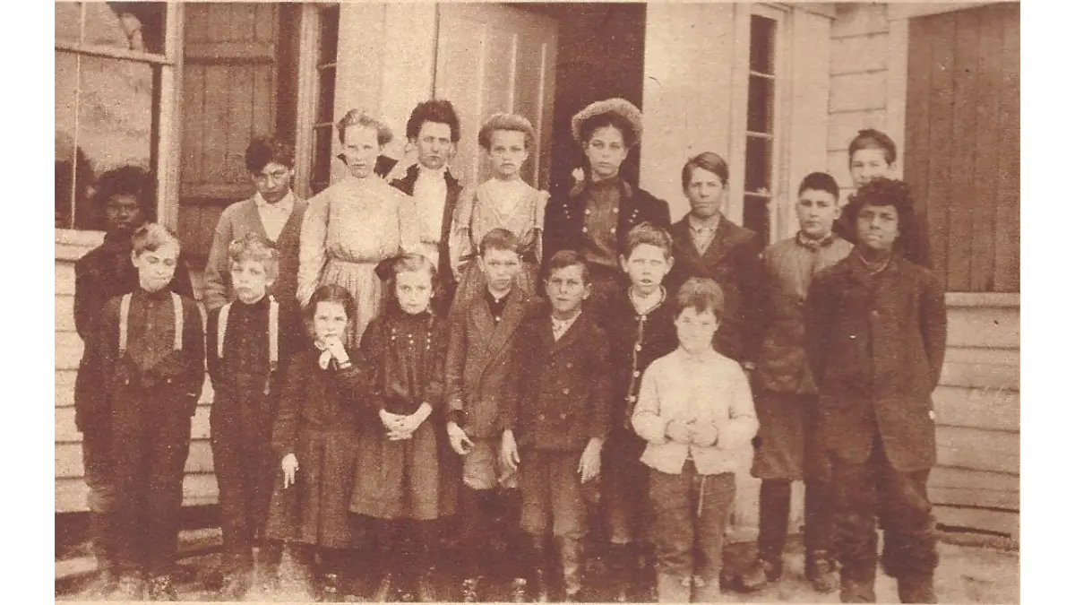
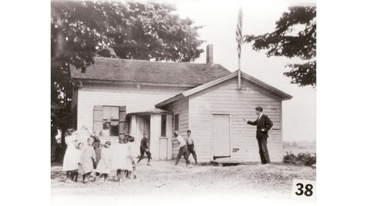
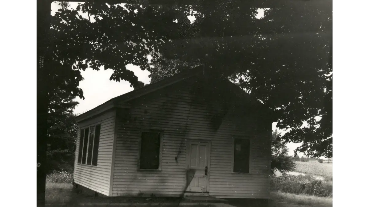
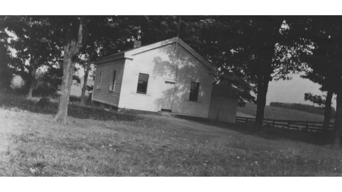
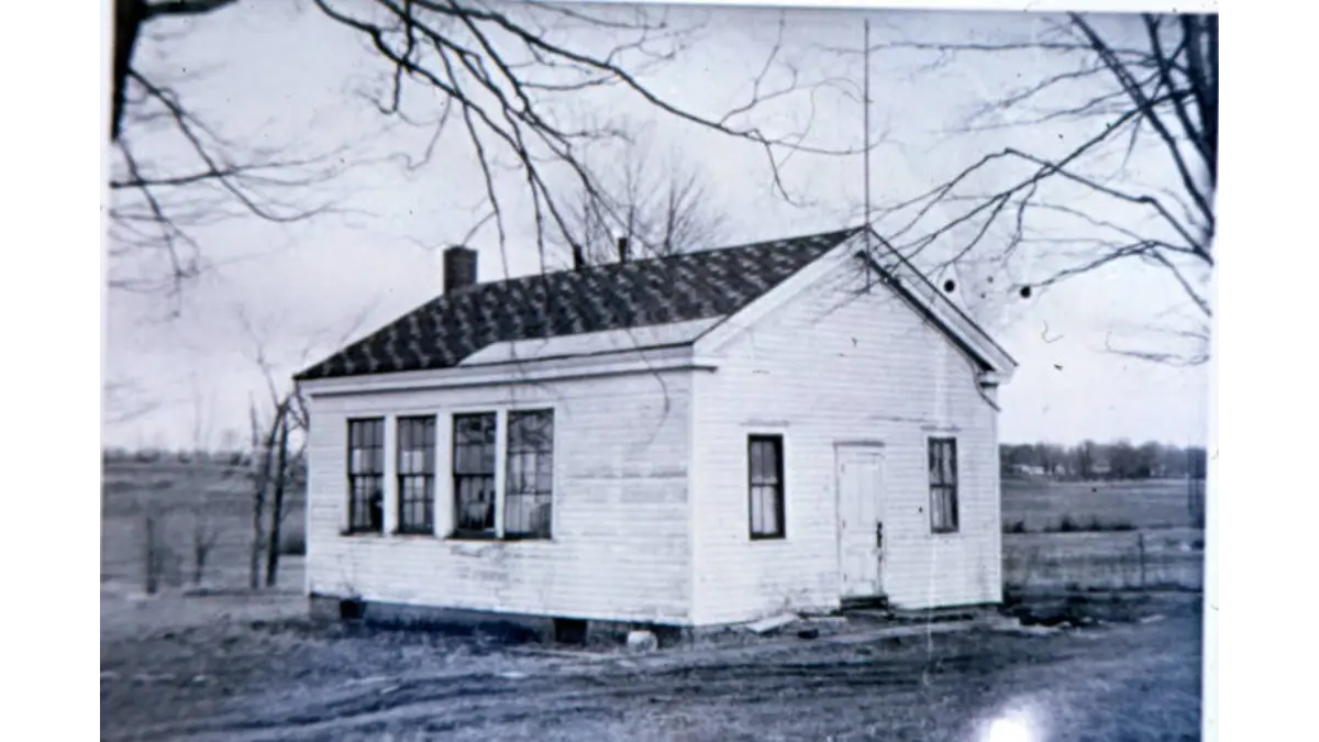
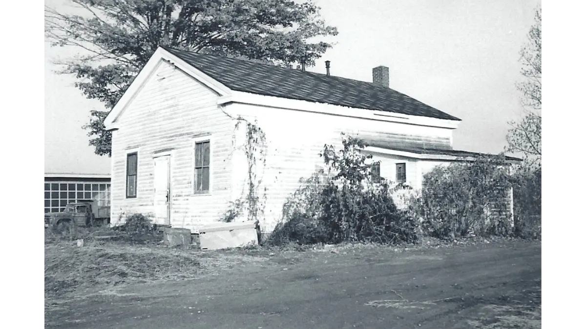
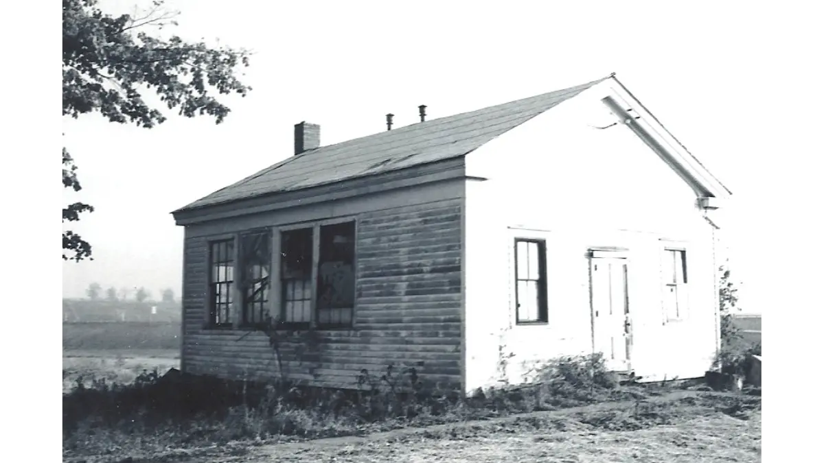
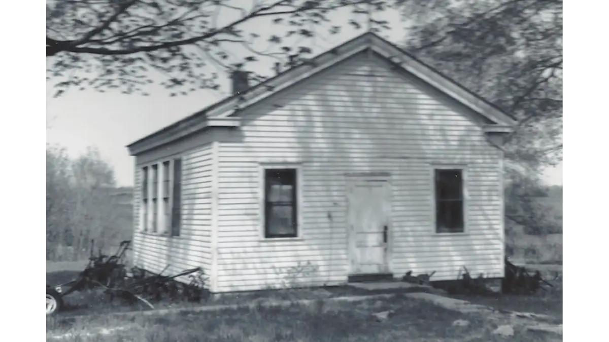
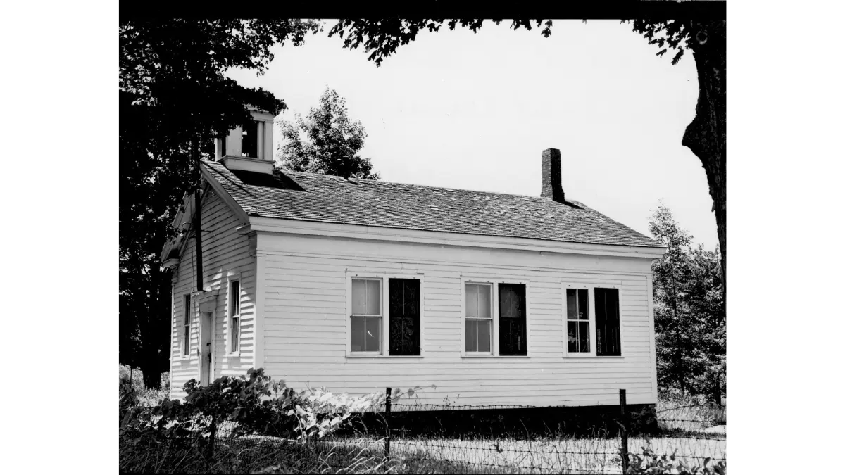
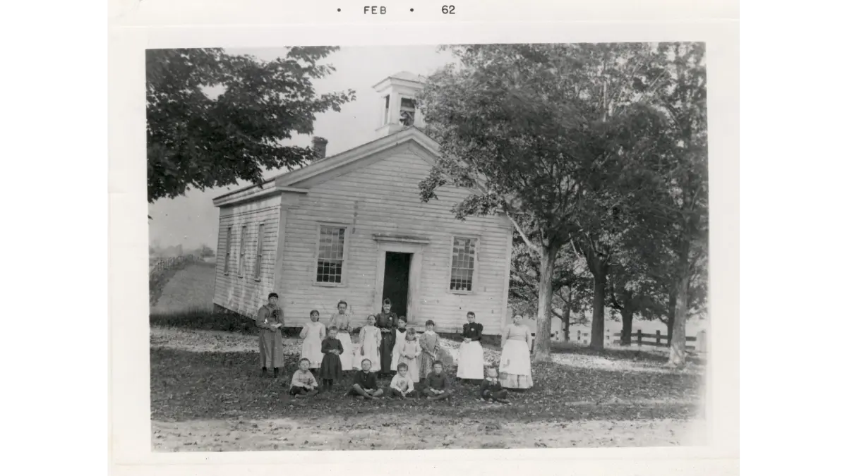
Early Schools
The following were the rural districts located in the town of Van Buren, until most of them were consolidated into the Baldwinsville Central School District circa 1949. Some images of these one-room schoolhouses are on display inside the Van Buren town hall and others are available online in the Christopher Collection at NYHeritage.org. The town of Van Buren is the exclusive repository of official records and reports relating to the town’s former rural school districts.
List of Early Schools (Image Gallery Below):
- Pleasant Valley – Located on the southeast corner of Kingdom and Perry Roads.
- Harrington – Located on the north side of Downer Street Road (Route 31) about where the South Gate entrance to Harbour Heights is now.
- Kingdom – Located on the northwest corner of Connors and Kingdom Roads.
- Stone Pile – Located on the southwest corner of Connors and West Dead Creek Roads.
- Daboll (Pine Hill) – Located on the southwest corner of Daboll and Kingdom Roads.
- Dolph – Located on the east side of Van Buren Road between its intersections with Jones Road and Herman Road.
- Sorrell Hill – Located on the northwest corner of East Sorrell Hill and Hoag Roads
- Shacksboro – Located on the east side of the intersection of Turner and Canton Street Roads, but relocated to the village of Baldwinsville in 1976, where it’s now the home of the Museum at the Shacksboro Schoolhouse.
- Hardscrabble – Located on the northeast corner of Van Buren and Peck Roads.
- Cooper Street (Maple Road) – Located west of State Fair Boulevard (Route 48) just south of its intersection with O’Brien Road. (no photo)
- Iona (Iona Corners) – Located south of Warners Road (Route 173) just east of its intersection with East Dead Creek Road (north) and Bennett’s Corners Road (south).
- Memphis – The only rural school in the town of Van Buren to consist of more than one room, it was located on the south side of Bennett’s Corners Road in the hamlet of Memphis.
- Name Unknown – Located on the east bank of Bentley Brook, on the north side of Warners Road (Route 173) just west of its intersection with East Sorrell Hill Road. (no photo)
- Warners – The second rural schoolhouse to be built in Warners, this brick building served as St. Paul’s Episcopal Church from 1898 through 1988.
- Number Unknown – Bangall (Sand Springs) – Located on the east bank of Dead Creek, on the north side of Hoag Road just west of its intersection with East Dead Creek Road, the section of which is now part of Route 31.
Explore the image gallery of early schools below. Use the tabs below to filter photos by school name, or select the “ALL” tab to view the entire collection.
- All
- Pleasant Valley
- Harrington
- Kingdom
- Stone Pile
- Daboll (Pine Hill)
- Dolph
- Sorrell Hill
- Shacksboro
- Hardscrabble
- Iona (Iona Corners)
- Memphis
- Warners
- Bangall (Sand Springs)
Helpful Links
The following are links to other free or not-for-profit sites that also have historical resources regarding the town of Van Buren.
Baldwinsville Public Library – A library housing a local history room that includes Baldwinsville’s largest collection of local history books. Baldwinsville Public Library Local History Room
Erie Canal Museum – A museum dedicated to the history of the Erie Canal, which formed the town of Van Buren’s southern border and flowed through two of our hamlets, Memphis and Warners. Erie Canal Museum
FultonHistory.com – A searchable database of thousands of historical newspapers from upstate New York, including many newspapers published in Baldwinsville beginning in the early 1800s. Fulton History
Lysander Town Historian – The webpage of the local historian for the town of Lysander, which neighbors the town of Van Buren on the north, including the northern half of the village of Baldwinsville. Lysander Town Historian
Museum at the Shacksboro Schoolhouse – A museum that features Baldwinsville’s largest collection of local historical artifacts. Shacksboro Schoolhouse Museum
New York Heritage – A searchable database of images from New York State, including all photographs from the collection of Tony Christopher, the town of Van Buren’s first and most prolific historian. New York Heritage
New York State Historic Newspapers – A searchable database of hundreds of historical newspapers, largely from northern New York. New York State Historic Newspapers
Onondaga Historical Association – A local history museum and organization located in nearby Syracuse. Onondaga Historical Association
The Erie Canal And Baldwinsville Legacy | Brews & Banter Podcast
Town Historian Steven McMahon joins event organizer Vickie Freyleue on the podcast Brews & Banter to discuss the October 3rd celebration on Paper Mill Island commemorating the Erie Canal’s historic “Wedding of the Waters.” The highlight of the event is the arrival of the Seneca Chief, a full-scale replica of the 1825 canal packet boat that once carried Governor DeWitt Clinton to New York City for the canal’s grand opening. As part of its symbolic journey from Buffalo to NYC along the Barge Canal, the Seneca Chief will make an overnight stop in Baldwinsville. The event will run from 4:30 to 7:30 p.m. and include music, history, a boat tour, and opportunities to reflect on the canal’s lasting impact.
In connection with this celebration, Town Historian Steven McMahon joined organizer Vickie Freyleue for an episode of Brews & Banter. Together they explore the Erie Canal’s origins, construction, and completion; its profound influence on the Haudenosaunee (Iroquois) nations; and how it transformed local trade, transportation, and settlement. The discussion also highlights Baldwinsville’s unique relationship with the canal, including the role of the Baldwin Canal and the ways in which the waterway shaped the village’s growth and prosperity.